Student researcher
Bushfires are a frequently occurring hazard in Australia, which can be devastating to rural communities and homes and infrastructure at rural-urban interfaces. The ability to understand and accurately predict the behaviour of a bushfire would be a major benefit for short-term emergency response and management, as well as long-term risk planning in fire-prone areas. Models to predict the rate of spread of a bushfire are based on experimental and field observations. These give a rate of spread for fire based on local environmental factors, such as wind terrain and fuel. Computational implementation of these models can predict the arrival time of a fire over a given region. However, these models lack accurate inputs for land cover and fuel conditions, as well as a detailed knowledge of fire propagation under complex conditions. This project focuses on integrating remotely sensed biophysical products, such as fuel load and moisture into predictive models for bushfire propagation.
This project is being undertaken by PhD student Andrea Massetti. The proejct involves investigating new methods to improve the actual capacity of prediction of 2d bushfire rate of spread models through the production of innovative products from high resolution remotely sensed data.
| Year | Type | Citation |
|---|---|---|
| 2020 | Report | Case study: use of remote sensing data to derive spatial and temporal explicit fuel accumulation curves across defence lands. (Bushfire and Natural Hazards CRC, 2020). |
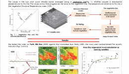
| 2019 | Journal Article | The Vegetation Structure Perpendicular Index (VSPI): A forest condition index for wildlife predictions. Remote Sensing of Environment 224, (2019). |


